Wonderful hiking trails in Ecuador, suitable for hikers of all levels
28.08.2025
BY Elmer2
BlogAndesToursTravel guide
HOW THIS ARTICLE IS DIFFERENT
This guide is aimed at people who want clear, practical arrival info (Where is the parking? Is there a visitor center? Are there cabins or signs?) and an honest picture of each hike.
The goal is to remove mystery: by the time you read the section for a trail, you’ll know exactly how to get there, what to expect at the trailhead, and why a local guide from Responsible Travel S.A. makes it all easier.
QUICK ORIENTATION: HIKING VS. TREKKING
A quick reminder:
Hiking here = single-day, marked trails, modest gear, no overnight packing.
Trekking= multi-day expeditions with camping or refuges, heavy packs, and tougher remoteness.
This article focuses on hiking — accessible outings that still deliver major views and cultural connection.
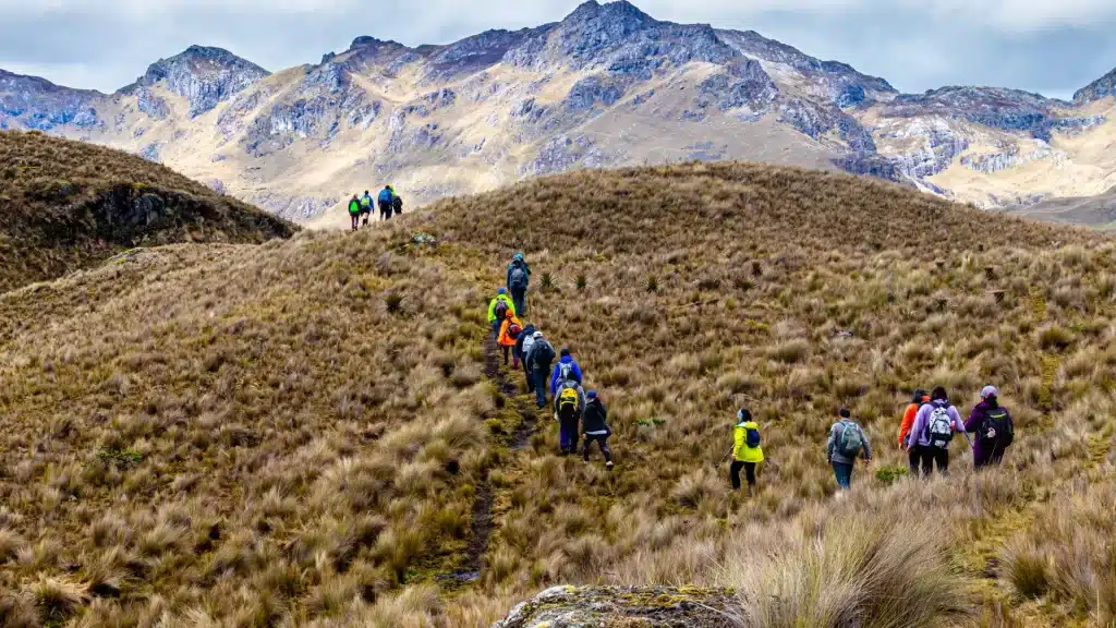
Exploring the high-altitude trails of Pichincha Volcano, where páramo landscapes meet dramatic Andean skies. Foto de Andres Medina en Unsplash
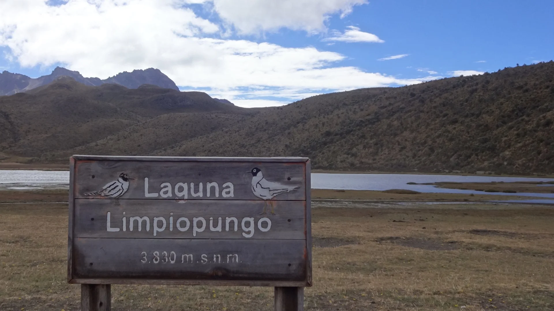
1) LIMPIOPUNGO LAGOON – COTOPAXI NATIONAL PARK (EASY, GREAT FOR ACCLIMATIZING)
Where it is and how to get there: Limpiopungo is located within Cotopaxi National Park, approximately 1.5-2 hours south of Quito by road.
Clearly marked from the highway, the main park entrance and visitor center at Cotopaxi National Park welcome visitors, with park staff efficiently managing parking and admission.
If you are coming from Quito, most visitors travel via Latacunga or join a guided transfer.
What you will find when you arrive: A paved access road, a small visitor/interpretation center, marked parking areas, basic public restrooms, and clear trail signage for the Limpiopungo circuit.
There are simple cabin/dormitory options and camping areas near La Rinconada for those who want to stay within the park.
Trail and experience: The Limpiopungo circuit is an easy, flat 1.6- to 2.6-kilometer trail around the lagoon; it takes between 1 and 1.5 hours at a leisurely pace.
The views of the Cotopaxi cone reflected in the water and the wildlife of the páramo (coots, ducks) are the highlights. It is an excellent acclimatization walk before undertaking higher hikes.
Why go with a guide: A local guide helps interpret the páramo plants, points out migratory birds, and schedules the visit so you can enjoy the best light.
Responsible Travel S.A. coordinates park permits and round-trip transportation so you can avoid long waits or parking problems.
The Limpiopungo Lagoon sign welcomes visitors to one of Cotopaxi National Park’s most scenic spots.
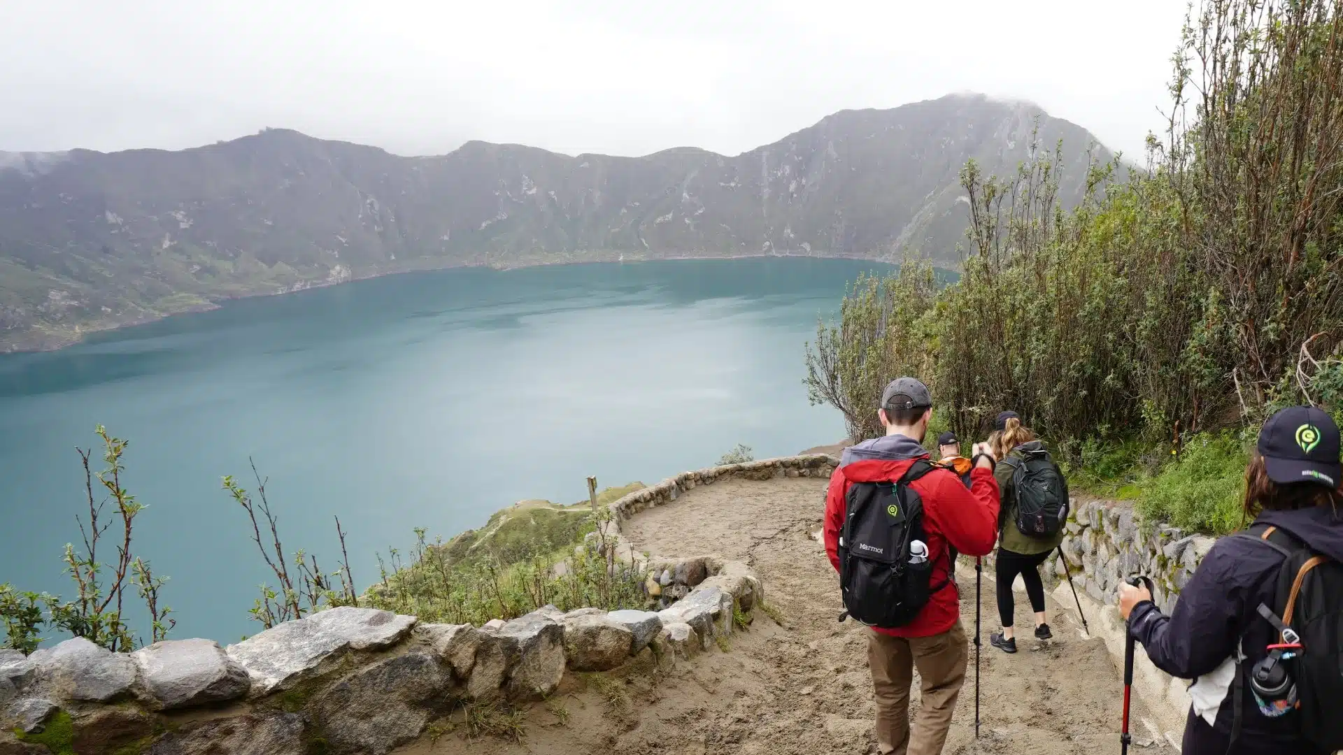
2) QUILOTOA CRATER LAKE (MODERATE – DRAMATIC RIM & CRATER DESCENT)
Where it is and how to get there: Quilotoa is located in the central Andes (province of Cotopaxi). You can easily reach the village on the edge of the crater by taking a bus or using private transport from Latacunga or Riobamba.
Many hikers set out from Sigchos, Chugchilán, or Isinlivi to complete the multi-day Quilotoa Looproute, but you can also visit Quilotoa on a day trip around the crater rim.
What you’ll find when you arrive: At the rim, there is a small visitor area with restaurants, craft stalls, viewpoints, and clear signage for the rim trail and the path down into the crater.
There are simple restrooms and parking; if you plan to spend the night nearby, there are hostels and small lodgings in Chugchilán and Isinlivi.
Trail and experience: The rim hike is easy to moderate and offers panoramic views of the emerald crater. When you head down to the water, get ready for a challenging climb back up. Many people complete the descent and return in 2-4 hours, depending on their fitness level.
For a more comprehensive route, the Quilotoa circuit is a 3-4 day trek connecting several villages.
Why go with a guide: Guides organize transportation (buses don’t always stop at the exact start of the trail), advise on the fastest and safest ascent routes.
Responsible Travel S.A. can book transfers in advance from Latacunga or towns in the highlands so you don’t miss the bus.
The emerald waters of Quilotoa Lagoon, one of Ecuador’s most breathtaking volcanic crater lakes.
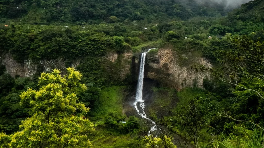
Where it is and how to get there: Mindo is located northwest of Quito, in the Imbabura/Pichincha region (about 2-3 hours by car from Quito). The waterfall sanctuary area is accessed by a short ride on the Tarabita (open cable car) that crosses the Nambillo River and drops you off at the trailhead.
There are buses and shared shuttles that go to the town of Mindo.
What you will find when you arrive: A small visitor reception area near the Tarabita, trail signage, guide kiosks, local cafes, and secure parking near the cable car. The trails leading to the waterfalls are marked; some have viewpoints with small entrance fees for maintenance.
The tarabita itself is a local feature, an open cable car that is part of the fun.
Trail and experience: The classic circuit takes in several waterfalls and natural pools; the total duration of the hike varies between 1.5 and 4 hours, depending on stops for swimming, bird watching, or taking photographs.
In the rainy season, expect muddy sections and slippery steps. Hummingbirds and orchids abound.
Why go with a guide: Local guides know which waterfalls have safe pools for swimming, the best places for bird watching, and how to navigate the trails after heavy rain.
Responsible Travel S.A. connects you with certified local naturalists and ensures that entrance fees go toward trail maintenance and the local economy.
Hidden deep in the cloud forest of Mindo, a cascading waterfall offers a refreshing escape into Ecuador’s wild heart.
4) EL CAJAS NATIONAL PARK – LAKES & PÁRAMO NEAR CUENCA (MODERATE – OTHERWORLDLY LAKES)
Where it is & how to get there:El Cajas lies west of Cuenca in Azuay province, with the main visitor center at Laguna Toreadora about 34 km from Cuenca (roughly a one-hour drive).
Regular buses and private transfers run from Cuenca’s Terminal Terrestre.
What you’ll find on arrival:The Toreadora visitor center (and ranger station) is well marked, with parking, a restroom, and clearly waymarked trails. Local restaurants at the visitor center often serve Andean soups and trout.
There is also limited refuge lodging and small campsites if you later choose to extend your visit.
Trail & experience: Several short loops (1–3 hours) circle highland lakes and offer dramatic rock formations and endemic páramo plants. Expect cold, windy conditions and quick weather changes.
Trails are well trodden but watch for boggy sections.
Why go with a guide: A local guide explains fragile páramo ecology, points out rare plants and birdlife, and helps time your visit for the best light and weather.
Responsible Travel S.A. organizes transport from Cuenca and secures park registration so you don’t get turned back by closures or ranger limits.
Trekking through the unique páramo landscapes of El Cajas National Park near Cuenca.
5) DEVIL’S NOSE (NARIZ DEL DIABLO) & ALAUSÍ – SHORT HIKES + ICONIC TRAIN RIDE (EASY – SCENIC & CULTURAL)
Where it is and how to get there:Alausíis located in the province of Chimborazo and is famous for the Nariz del Diablo zigzag railway.
The city can be reached by bus and train from Riobamba and other centers in the central highlands.
What you’ll find when you arrive: The Alausí station area is a small colonial town with a central plaza, cafes, and clear signs pointing to the Devil’s Nose viewpoint and the short trails below the train tracks.
Local guides offer walking tours that allow you to take in the impressive canyon and railway engineering.
Trail and experience: The short walks around the viewpoint are easy and reward you with spectacular views of the canyon.
Many visitors combine a short walk with the train experience (a spectacular 45- to 90-minute ride, depending on the service).
Why go with a guide: Guides will show you the best viewpoints, explain the history of the railroad, and help you with local train ticket options.
Responsible Travel S.A. can book train seats in advance and organize the short walks so you can make the most of your time taking photos and minimize waiting.
The iconic Nariz del Diablo railway zigzag in Alausí, an engineering marvel of the Ecuadorian Andes.
A COMPACT COMPARISON (QUICK GLANCE)
Trail
Nearest city
Trail time (avg)
Trailhead features
Limpiopungo (Cotopaxi)
Quito / Latacunga
1–1.5 hrs
Visitor center, parking, cabins/campsites.
Quilotoa rim & crater
Latacunga / Chugchilán
2–4 hrs (rim)
Rim viewpoints, vendors, small hostels; clear signage.
Altitude: Even day hikes at 3,000 – 4,000 m need respect. Hydrate and move steadily.
Weather: Bring a lightweight rain shell and warm layers; the Andes change fast.
Footing: Trails can be muddy and rocky, good tread on your shoes matters.
Money: Small entrance fees or local donations are often cash-only.
Local support: Hiring a local guide helps with language, safety, and connecting with community businesses.
WHY RESPONSIBLE TRAVEL S.A. HELPS YOU GET THE MOST FROM A DAY HIKE
We are an Ecuador – German local partner that curates safe, authentic hiking days. Here’s how we add value: we time your transfers for maximum trail time, arrange certified naturalist guides, prebook park registrations where required.
We also coordinate with fellow local agencies and lodges that maintain trails and visitor services – because collaboration keeps access sustainable and communities strong.
PICK A DAY, PACK LIGHT, AND GO
If you wish, I can now:
convert any of these sections of the route into a one-page printable hiking planner (directions, pick-up times, equipment list), or
Create a sample one-day itinerary from Quito/Cuenca that Responsible Travel S.A. can offer as a tourist product.
FAQ: Day Hiking in Ecuador
1) How is day hiking different from trekking?
Hiking is a single-day activity that doesn’t require heavy gear or camping. It’s perfect for a quick adventure.
Do I need a guide for a day hike?
While many trails are accessible, a local guide can enhance your experience with cultural and natural insights.
What should I pack for a day hike?
Light layers, comfortable hiking shoes, water, sunscreen, and a small backpack for personal items.
Are there any short hikes with spectacular views?
Yes. The hike to the Quilotoa Lagoon and the trails around the Limpiopungo Lagoon offer amazing views in a short time.
Can I find hiking trails near major cities like Quito?
Absolutely. Many national parks and reserves with excellent hiking trails are just a short drive from Quito and other major cities.
Wonderful hiking trails in Ecuador, suitable for hikers of all levels
28.08.2025
BY Elmer2
BlogAndesToursTravel guide
HOW THIS ARTICLE IS DIFFERENT
This guide is aimed at people who want clear, practical arrival info (Where is the parking? Is there a visitor center? Are there cabins or signs?) and an honest picture of each hike.
The goal is to remove mystery: by the time you read the section for a trail, you’ll know exactly how to get there, what to expect at the trailhead, and why a local guide from Responsible Travel S.A. makes it all easier.
QUICK ORIENTATION: HIKING VS. TREKKING
A quick reminder:
Hiking here = single-day, marked trails, modest gear, no overnight packing.
Trekking= multi-day expeditions with camping or refuges, heavy packs, and tougher remoteness.
This article focuses on hiking — accessible outings that still deliver major views and cultural connection.
Exploring the high-altitude trails of Pichincha Volcano, where páramo landscapes meet dramatic Andean skies. Foto de Andres Medina en Unsplash
1) LIMPIOPUNGO LAGOON – COTOPAXI NATIONAL PARK (EASY, GREAT FOR ACCLIMATIZING)
Where it is and how to get there: Limpiopungo is located within Cotopaxi National Park, approximately 1.5-2 hours south of Quito by road.
Clearly marked from the highway, the main park entrance and visitor center at Cotopaxi National Park welcome visitors, with park staff efficiently managing parking and admission.
If you are coming from Quito, most visitors travel via Latacunga or join a guided transfer.
What you will find when you arrive: A paved access road, a small visitor/interpretation center, marked parking areas, basic public restrooms, and clear trail signage for the Limpiopungo circuit.
There are simple cabin/dormitory options and camping areas near La Rinconada for those who want to stay within the park.
Trail and experience: The Limpiopungo circuit is an easy, flat 1.6- to 2.6-kilometer trail around the lagoon; it takes between 1 and 1.5 hours at a leisurely pace.
The views of the Cotopaxi cone reflected in the water and the wildlife of the páramo (coots, ducks) are the highlights. It is an excellent acclimatization walk before undertaking higher hikes.
Why go with a guide: A local guide helps interpret the páramo plants, points out migratory birds, and schedules the visit so you can enjoy the best light.
Responsible Travel S.A. coordinates park permits and round-trip transportation so you can avoid long waits or parking problems.
The Limpiopungo Lagoon sign welcomes visitors to one of Cotopaxi National Park’s most scenic spots.
2) QUILOTOA CRATER LAKE (MODERATE – DRAMATIC RIM & CRATER DESCENT)
Where it is and how to get there: Quilotoa is located in the central Andes (province of Cotopaxi). You can easily reach the village on the edge of the crater by taking a bus or using private transport from Latacunga or Riobamba.
Many hikers set out from Sigchos, Chugchilán, or Isinlivi to complete the multi-day Quilotoa Looproute, but you can also visit Quilotoa on a day trip around the crater rim.
What you’ll find when you arrive: At the rim, there is a small visitor area with restaurants, craft stalls, viewpoints, and clear signage for the rim trail and the path down into the crater.
There are simple restrooms and parking; if you plan to spend the night nearby, there are hostels and small lodgings in Chugchilán and Isinlivi.
Trail and experience: The rim hike is easy to moderate and offers panoramic views of the emerald crater. When you head down to the water, get ready for a challenging climb back up. Many people complete the descent and return in 2-4 hours, depending on their fitness level.
For a more comprehensive route, the Quilotoa circuit is a 3-4 day trek connecting several villages.
Why go with a guide: Guides organize transportation (buses don’t always stop at the exact start of the trail), advise on the fastest and safest ascent routes.
Responsible Travel S.A. can book transfers in advance from Latacunga or towns in the highlands so you don’t miss the bus.
The emerald waters of Quilotoa Lagoon, one of Ecuador’s most breathtaking volcanic crater lakes.
Where it is and how to get there: Mindo is located northwest of Quito, in the Imbabura/Pichincha region (about 2-3 hours by car from Quito). The waterfall sanctuary area is accessed by a short ride on the Tarabita (open cable car) that crosses the Nambillo River and drops you off at the trailhead.
There are buses and shared shuttles that go to the town of Mindo.
What you will find when you arrive: A small visitor reception area near the Tarabita, trail signage, guide kiosks, local cafes, and secure parking near the cable car. The trails leading to the waterfalls are marked; some have viewpoints with small entrance fees for maintenance.
The tarabita itself is a local feature, an open cable car that is part of the fun.
Trail and experience: The classic circuit takes in several waterfalls and natural pools; the total duration of the hike varies between 1.5 and 4 hours, depending on stops for swimming, bird watching, or taking photographs.
In the rainy season, expect muddy sections and slippery steps. Hummingbirds and orchids abound.
Why go with a guide: Local guides know which waterfalls have safe pools for swimming, the best places for bird watching, and how to navigate the trails after heavy rain.
Responsible Travel S.A. connects you with certified local naturalists and ensures that entrance fees go toward trail maintenance and the local economy.
Hidden deep in the cloud forest of Mindo, a cascading waterfall offers a refreshing escape into Ecuador’s wild heart.
4) EL CAJAS NATIONAL PARK – LAKES & PÁRAMO NEAR CUENCA (MODERATE – OTHERWORLDLY LAKES)
Where it is & how to get there:El Cajas lies west of Cuenca in Azuay province, with the main visitor center at Laguna Toreadora about 34 km from Cuenca (roughly a one-hour drive).
Regular buses and private transfers run from Cuenca’s Terminal Terrestre.
What you’ll find on arrival:The Toreadora visitor center (and ranger station) is well marked, with parking, a restroom, and clearly waymarked trails. Local restaurants at the visitor center often serve Andean soups and trout.
There is also limited refuge lodging and small campsites if you later choose to extend your visit.
Trail & experience: Several short loops (1–3 hours) circle highland lakes and offer dramatic rock formations and endemic páramo plants. Expect cold, windy conditions and quick weather changes.
Trails are well trodden but watch for boggy sections.
Why go with a guide: A local guide explains fragile páramo ecology, points out rare plants and birdlife, and helps time your visit for the best light and weather.
Responsible Travel S.A. organizes transport from Cuenca and secures park registration so you don’t get turned back by closures or ranger limits.
Trekking through the unique páramo landscapes of El Cajas National Park near Cuenca.
5) DEVIL’S NOSE (NARIZ DEL DIABLO) & ALAUSÍ – SHORT HIKES + ICONIC TRAIN RIDE (EASY – SCENIC & CULTURAL)
Where it is and how to get there:Alausíis located in the province of Chimborazo and is famous for the Nariz del Diablo zigzag railway.
The city can be reached by bus and train from Riobamba and other centers in the central highlands.
What you’ll find when you arrive: The Alausí station area is a small colonial town with a central plaza, cafes, and clear signs pointing to the Devil’s Nose viewpoint and the short trails below the train tracks.
Local guides offer walking tours that allow you to take in the impressive canyon and railway engineering.
Trail and experience: The short walks around the viewpoint are easy and reward you with spectacular views of the canyon.
Many visitors combine a short walk with the train experience (a spectacular 45- to 90-minute ride, depending on the service).
Why go with a guide: Guides will show you the best viewpoints, explain the history of the railroad, and help you with local train ticket options.
Responsible Travel S.A. can book train seats in advance and organize the short walks so you can make the most of your time taking photos and minimize waiting.
The iconic Nariz del Diablo railway zigzag in Alausí, an engineering marvel of the Ecuadorian Andes.
A COMPACT COMPARISON (QUICK GLANCE)
Trail
Nearest city
Trail time (avg)
Trailhead features
Limpiopungo (Cotopaxi)
Quito / Latacunga
1–1.5 hrs
Visitor center, parking, cabins/campsites.
Quilotoa rim & crater
Latacunga / Chugchilán
2–4 hrs (rim)
Rim viewpoints, vendors, small hostels; clear signage.
Altitude: Even day hikes at 3,000 – 4,000 m need respect. Hydrate and move steadily.
Weather: Bring a lightweight rain shell and warm layers; the Andes change fast.
Footing: Trails can be muddy and rocky, good tread on your shoes matters.
Money: Small entrance fees or local donations are often cash-only.
Local support: Hiring a local guide helps with language, safety, and connecting with community businesses.
WHY RESPONSIBLE TRAVEL S.A. HELPS YOU GET THE MOST FROM A DAY HIKE
We are an Ecuador – German local partner that curates safe, authentic hiking days. Here’s how we add value: we time your transfers for maximum trail time, arrange certified naturalist guides, prebook park registrations where required.
We also coordinate with fellow local agencies and lodges that maintain trails and visitor services – because collaboration keeps access sustainable and communities strong.
PICK A DAY, PACK LIGHT, AND GO
If you wish, I can now:
convert any of these sections of the route into a one-page printable hiking planner (directions, pick-up times, equipment list), or
Create a sample one-day itinerary from Quito/Cuenca that Responsible Travel S.A. can offer as a tourist product.
FAQ: Day Hiking in Ecuador
1) How is day hiking different from trekking?
Hiking is a single-day activity that doesn’t require heavy gear or camping. It’s perfect for a quick adventure.
Do I need a guide for a day hike?
While many trails are accessible, a local guide can enhance your experience with cultural and natural insights.
What should I pack for a day hike?
Light layers, comfortable hiking shoes, water, sunscreen, and a small backpack for personal items.
Are there any short hikes with spectacular views?
Yes. The hike to the Quilotoa Lagoon and the trails around the Limpiopungo Lagoon offer amazing views in a short time.
Can I find hiking trails near major cities like Quito?
Absolutely. Many national parks and reserves with excellent hiking trails are just a short drive from Quito and other major cities.